• About

Lost Mosman

Lost Mosman

Category Archives: Uncategorized

Trafalgar, 68 Bradleys Head Road, Mosman

21 Wednesday Nov 2018

Posted by David Carment in Uncategorized

≈ Leave a comment

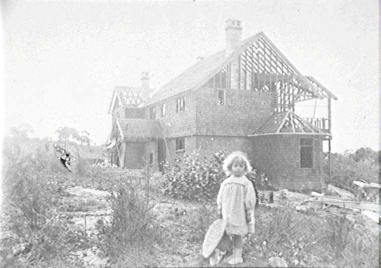
Trafalgar in c1910 (Our Beautiful Homes)

In 1908 William Wells Robinson, and his wife Charlotte, built a large Federation mansion at 68 Bradleys Head Road (previously known as No 52), on the corner of Queen Street. Married in 1883, they and their children previously lived in a home named Trafalgar in Singleton, so named because William’s grandfather fought at the Battle of Trafalgar. They also gave the same name to their new residence in Mosman. Unfortunately Charlotte died the following year; however William and his second wife Mary lived in the house for many years until his death in 1947, aged 89. It was advertised as ‘a Gentleman’s residence of brick’ in 1939 but apparently not sold. His daughter Myra was also living with him in the 1940s. Frank Robinson was his other child. Mosman Council assessment notices have Mrs Joan Chapman as a new owner in 1949.

William was admitted as a solicitor in 1883 and became a partner in the Singleton firm owned by Sir Albert J Gould. He was known locally as a philanthropist and was one of the partners (and the solicitor) in the Cobar Syndicate which took over the Singleton copper mines. After his move to Sydney in 1908 he continued to practice as a solicitor and held directorships with the Victoria Park Racecourse and Australian Woollen Mills Ltd.

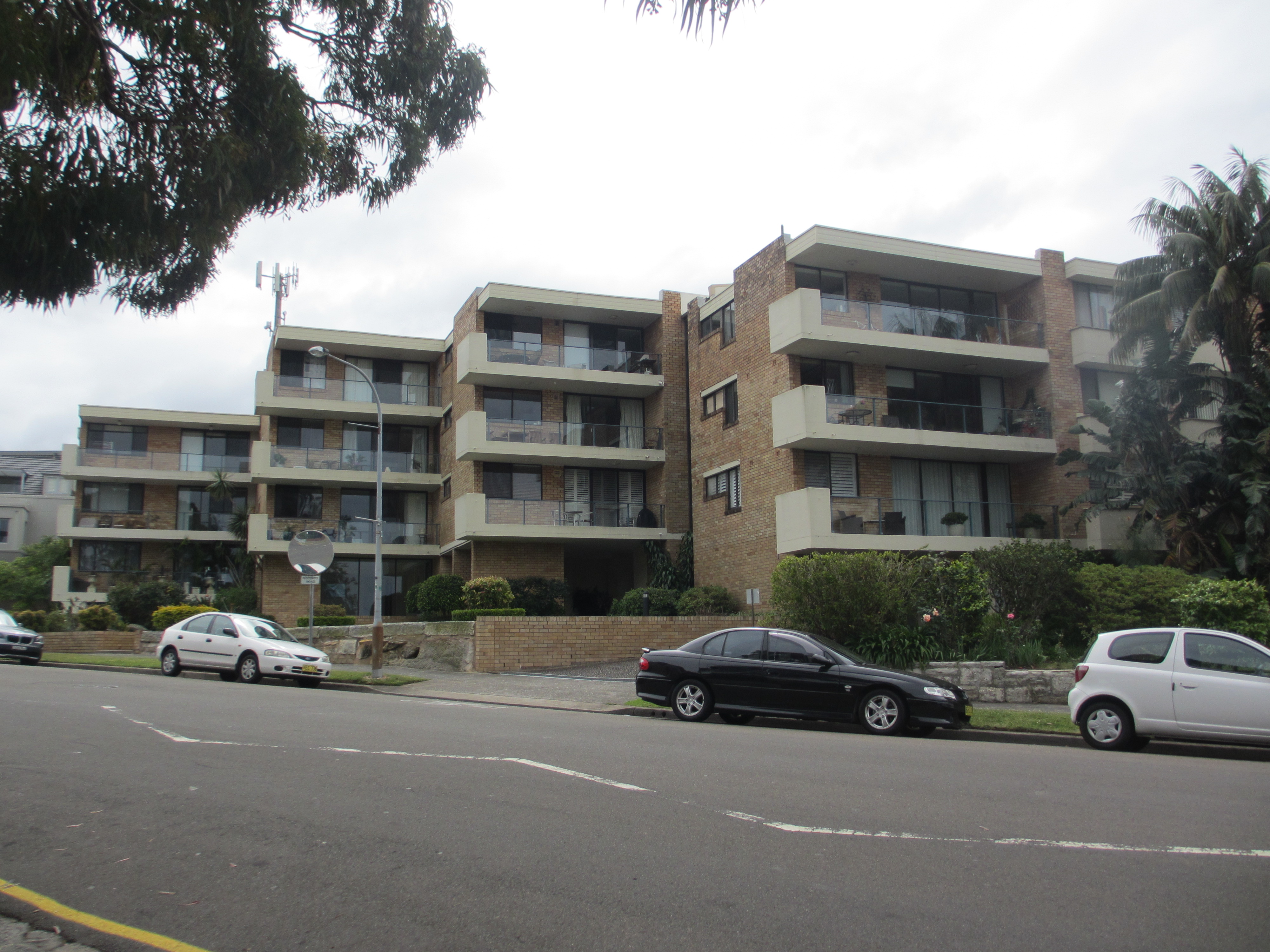
In early 1956, Trafalgar was converted to flats by the architect, A Ashton of 27 Hopetoun Avenue, Mosman.

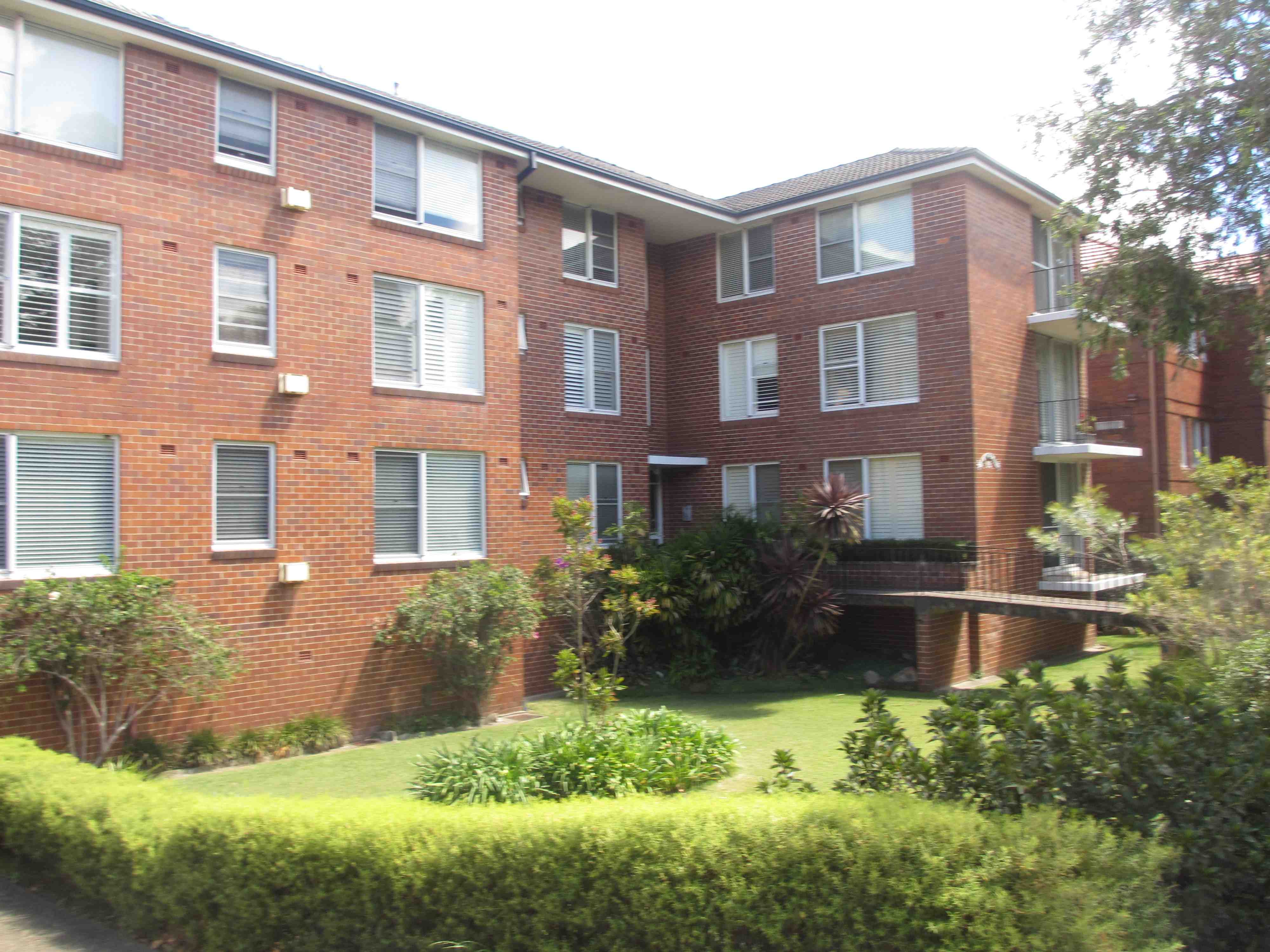
An application to Mosman Council in February 1962 sought to build a ‘car service station’ on the site. This was refused. The following month an application was lodged for the building to become a private convalescent hospital – this was also refused. Then in November 1962 approval was given for a three-storey block of 18 flats on the site and Trafalgar was demolished.

Soon after Trafalgar was completed the house was featured in Our Beautiful Homes, a c1910 book with photographs of what were considered to be Sydney’s best mansions in the new Edwardian style. The publisher sought to ‘provide our fellow subjects of Greater [sic] Britain with the opportunity of seeing something of the conditions under which we live, and of the ideals of House and Home which inspire us in New South Wales’ (p 13). Most of the pictured mansions were ‘the realisation of self-made wealth’ with barristers, solicitors and politicians well represented.

Trafalgar drawing room c1910 (Our Beautiful Homes)

So why would such a building be demolished less than 55 years later? A clue to prevailing attitudes towards Federation buildings in the 1960s is provided in the new introduction to a 1977 reprint of Our Beautiful Homes. The author noted that Georgian and Victorian buildings in Sydney were starting to be revered, however he could see no possibility that Edwardian buildings such as were photographed for the book would ever be similarly valued. He condemned most of the architecture in the book as being a ‘mess of bits and pieces’ and ‘architectural humiliations’ (p 5).

One might argue today that being replaced by a bland 1960s block of flats was the ultimate humiliation for Trafalgar.

(Pam Lofthouse, 2018)

Sources

Electoral Rolls, 1943.

Phillipa Morris, research information, 2018.

Mosman Council, Building Applications Card, 68 Bradleys Head Road.

New South Wales, Deaths and Marriages. Online.

Obituary for Mr William Robinson, Singleton Argus, 4 June 1947, p 2.

Our Beautiful Homes, Series 2. Edward Lee & Co, Sydney, c1910.

Our Beautiful Homes NSW, Edward Lee & Co, Sydney, 1977.

Sands Directories.

Pam Lofthouse

Blakesley – Home of the Muston Family, 60 and then 84 Bradleys Head Road Mosman

11 Wednesday Apr 2018

Posted by David Carment in Uncategorized

≈ Leave a comment

Arthur Muston, a banker and merchant, was born in North Sydney in 1856, his family being early settlers on the North Shore. Growing up in the area he recognised the potential of the nearby Mosman area and, in the 1880s, began purchasing land there. One of Mosman’s early speculators, he owned land in the area near Muston Street, eventually named after him, and built a ‘model village’ of desirable homes in Keston Street and Gladstone Avenue. By 1883 he also held most of a triangular area bounded by what are now Prince Albert Street, Queen Street and Bradleys Head Road, originally part of James King’s Silex Estate grant.

Having married Henrietta Bull in 1880, in 1883 Muston began construction of a family home, Blakesley, in Bradleys Head Road, on an acre of his land between what is now the Warringah Bowling Club and Mosman Police Station. Blakesley first appeared in Sands Directory in 1884 (in Military Road) – Bradleys Head Road only appeared under that name in 1887, having just four residents at the time. Initially only house names were used for identification, but when street numbers were introduced in 1913 Blakesley became number 60, then later number 84 Bradleys Head Road after 1924.

Blakesley was a family name, that of Arthur Muston’s English grandmother Ann Blakesley. Over time however the name acquired sad associations. Arthur and Henrietta’s second son Arthur Blakesley Muston died in infancy, as did a grandson who also bore the name.

The Mustons lived at Blakesley during the 1880s, but in February 1889 it was advertised for let. It was described as having ‘8 rooms, bathroom, kitchen etc, two-stall stable, coach house, man’s room and large yard, city water, near tram’ (Sydney Morning Herald, 23 February 1889, p 19). Apparently there were no immediate takers because not until 1894 were they listed at a new address, Terralta in Prince Albert Street. Also built by Arthur Muston on part of his landholding, it was behind Blakesley and connected by a laneway. From then on Sands Directory lists a number of different tenants at Blakesley, including Richard Hayes Harnett. By c1910 Arthur and Henrietta Muston’s eldest son John had married Vere McMahon, and his family remained at Terralta, while Arthur, whose wife Henrietta died in 1911, eventually moved away from Mosman. He built a home on the waterfront at Wunulla Road, Point Piper, close to his yacht club, where he could moor his boat at the foot of his garden and indulge his passion for sailing. He died in 1948.

John and Vere Muston remained at Blakesley for the rest of their lives, John dying in 1934 and Vere in 1951. Photographs show Blakesley as a substantial single storey Victorian style house with large grounds, which their granddaughter, Jacqueline Morgan, remembers well. A rear garden kitchen and small orchard occupied the south-western area of the site, and to the north was a large lawn which became a tennis court. The house faced northwards towards the tennis court, though the front entrance was on the eastern side facing Bradleys Head Road. A driveway, on the northern border near the police station, provided access from Prince Albert Street and also to Terralta, the other Muston residence.

Mosman Council had in 1937 made changes to residential zoning, allowing the building of flats in selected areas along the ridges and close to shopping centres. This section of Bradleys Head Road was included in one of these areas so the Muston family, following John’s death, apparently made the decision to subdivide and sell some of the land adjoining Blakesley. This was advertised for sale in the Sydney Morning Herald on 18 September 1937, but not until 1940 were two lots, between the house and the police station, sold. Mosman valuation lists of 1941 show that blocks of flats were under construction at numbers 88 and 90 Bradleys Head Road, land previously part of Blakesley.

Following Vere Muston’s death in 1951, the property was passed to Horace Kenneth Muston who lived there for just a short time. In 1955 Blakesley was finally sold out of Muston family hands, the new owners being Dr James and Mrs Marion Sherwood. In February 1963 it was again sold, this time to Vernon Alston, a builder of Harbord. Home unit construction was at this time starting to take off in Mosman. In November 1962 Alston had sought, and been granted, approval in principle to build on the site a three storey block of 15 flats – six with two bedrooms each and nine with one bedroom each – at a cost of 37,000 Pounds. Blakesley was at that time described as a ‘dwelling converted into 2 flats’.

Mosman Council Building Application Number 63/63 gave final approval for this plan. A condition of the approval was for ‘existing shrubs, small trees and landscaping on the southern boundary and along the street front being retained’. Demolition of the old house and construction of the flats, now 84-86 Bradleys Head Road and also named Blakesley, was completed, and the final inspection certificate issued by 26 September 1963. It is one of Mosman’s earliest Strata Plan unit blocks. All that remains of one of Mosman’s earliest homes, built by one of the fathers of Mosman, Arthur Muston, is part of the old stone wall and steps bordering the footpath of Bradleys Head Road.

Sources

Jack Carroll, The Mosman That Was, 1789-1900, Mosman, 1949.

Mosman Council building applications.

Mosman Council valuation lists, 1926-1950.

New South Wales Land and Property information.

Notes and photographs kindly lent by Mrs Jacqueline Morgan (nee Muston).

Sands Directories, 1880-1924.

Gavin Souter, Mosman: A History, Melbourne University Press, Melbourne, 1994.

Sydney Morning Herald, various articles.

Blakesley in early twentieth century (Mosman Library)

84 Bradleys Head Road in 2018 (Phillipa Morris)

Phillipa Morris

The Balmoral Tram

12 Tuesday Sep 2017

Posted by David Carment in Uncategorized

≈ 2 Comments

In 1886 the first tram to run on Sydney’s North Shore was a cable tram that ran from Milsons Point to the top of Ridge Street. This line was extended to Spit Junction in 1893 using an electric tram. It was not until 1897 that the line was extended along Military Road to Mosman Wharf and in 1917 to Taronga Zoo and Athol Wharf.

Visitors to Balmoral now had two ways of accessing Balmoral Beach: by ferry or by tram to Mosman Junction or Milsons Point to Mosman Junction and then walking down the Balmoral Slopes.

As early as 1902 discussions were held as to extending the line to Balmoral but because of the topgraphy it was considered too difficult and was constantly being put on the back burner.

With the increase in pleasure seekers to Balmoral it was eventually decided to build a line to Balmoral. The two options were down Raglan Street or Awaba Street using the Spit Junction to the Spit Line that had opened in 1900.

In 1919 the line from Mosman Junction had been extended to Georges Heights to serve the limited population and the patients from the military hospital there.

Eventually in 1922 the line to Balmoral via Middle Head Road , Street Gordon and Beaconsfield Road was built. The Georges Heights line was stopped at Gordon Street to enable the start of the Balmoral line. Because of the terrain, after leaving Gordon Street the line had to gradually descend the slope to Balmoral via a cutting, reverse curves reminscent of railway construction from Beaconsfield Street to the end of Mulbring Street and then via a cutting through the bush to arrive at Balmoral opposite Shearers Baths. It was then extended along Ruve Street, which became known as Lawry Parade and is now The Esplanade. At the terminus there was a scissors crossover so the tram could reverse its journey. The original tram shed at Balmoral still exists today.

In 1923 a line was built down King Max Street so that people arriving by ferry could catch the tram down to Balmoral. By 1932 it was possible to catch a tram all the way from Wynyard to Balmoral.

The Balmoral tram was one of the last trams to run on the North Shore when the system was closed in 1958.

According to some locals once the line was torn up the lower end of the track through the bush was often called ‘Lovers Lane’. Today the walking track through the bush at the end of Mulbring Street is well used.

Some tram tracks and wires have been replaced at the end of the cutting just as it reaches Balmoral to recreate the historical setting.

Sources

David R Keenan, The North Sydney Lines of the Sydney Tramway System, Transit Press, Sans Souci, 1987.

Gavin Souter, Mosman: A History, Melbourne University Press, Melbourne, 1994.

A tram travelling through bushland to Balmoral, 1940s (Mosman Library)

133. Balmoral

A tram travelling along Ruve Street in 1927 (Mosman Library)

Tram route

Aerial photograph of the tram route in 1943 (Roads and Maritime Services)

Noela Gill

Footbridge, Mosman Bay, Mosman

31 Wednesday Aug 2016

Posted by David Carment in Uncategorized

≈ Leave a comment

Crossing Mosman Bay to reach the track to Neutral Bay was difficult from the earliest times. At high tide boats could be used, but at low tide the slippery mud flats were hazardous. Before reclamation for Reid Park, the alternative was a long walk around the head of the bay, scrambling over rocks and around waterfalls.

From the days of whaling in the 1830s various solutions were attempted. Stones were piled across the bay to create a rough causeway, but were constantly displaced by the tides. The first bridge was constructed around 1880 by local resident Captain Blix. Photos show a rudimentary structure with split palings for planking, and railings made from saplings and bamboo from the nearby Rangers estate. Despite its fragile appearance it survived for almost 20 years.

In 1899 a decision was made by the New South Wales government to dredge the upper part of Mosman Bay, and use the silt, to be pumped behind a new retaining wall, to create what would become Reid Park. In order to allow access for the dredges however, it was ‘necessary to remove the old rustic bridge…between the eastern and western shores’. Following the dredging and filling, and simultaneously with associated storm water works in the park, a new passenger bridge was to be erected. By March 1901 the new bridge, much more substantial that its predecessor, was under construction. It was a low level pile bridge with a footway six feet wide, and a set of landing steps to water level to allow access to small craft. It featured a large central span, designed to allow its temporary removal to enable access for dredging, which would be necessary from time to time. Construction was delayed due to difficulties obtaining enough timber, but by 1902 the bridge was completed, allowing a safer approach from the far shore to the ferry wharf.

Over the years the bridge became a feature in photographs, post cards and paintings of Mosman Bay, but its maintenance was an ongoing burden for Mosman Council. In January 1940 Alderman Osborne complained to the Council that the Mosman Bay footbridge was in a deplorable condition. It was a picturesque addition to the landscape, ‘a very fine structure which we would be sorry to lose’, but was in urgent need of repair and painting. The Council Engineer reported that the landing steps were dangerous and had been closed for 12 months, and a girder and 75 per cent of the planking needed replacement. Various temporary repairs had been made just to keep it patched up, as it was understood the government planned to remove it altogether to facilitate dredging. This had not happened. The question of ownership then arose, and who had built it. It was concluded that though the footbridge had been built by the New South Wales Works Department for the benefit of Mosman residents, the municipality had always maintained it and was responsible for the repairs required. The use of Employment Relief Labour was suggested but rejected. Eventually the Council agreed to pay the 175 Pounds for the necessary work. Later photos show the bridge without the landing steps, so it was likely that they were removed rather than repaired at this time.

Around 1956 the Mosman Bay Marina was constructed adjacent to the footbridge, and by the 1960s the Marina owners were keen to expand. The bridge was in their way and its demolition was requested. In addition, the Maritime Services Board complained to Council that it interfered with dredging of the bay. By this time the bridge was over 60 years old, in disrepair and beginning to rot, and by early 1967 was closed due to its dangerous condition, In November that year it partially collapsed at the western end. Mosman Council claimed that the $10,000 required for repairs was too expensive, and in early 1968 the bridge was demolished. Residents protested about having a longer walk around the bay via Reid Park but, despite Council promises to the contrary, the bridge was never replaced.

Sources

Graeme Andrews, ‘The Mosman Bay Footbridge’, in Afloat, August 2008.

Evening News, 25 January 1899.

Mosman Daily, 19 January 1940, 20 February 1940, 8 November 1967, 1 June 1968, 9 March 1973.

Rob Sturrock, A Pictorial History of Mosman, vol 1, Griffin Press, Netley, 1982, p 62.

Sydney Morning Herald, 19 June 1900, 1 March 1901.

old bridge

Old footbridge (1880-1899) at Mosman Bay (Mosman Library)

1966photo120160630_18191361

New bridge (1901-1968) at Mosman Bay in 1966 (Mosman Library)

IMG_7526

Mosman Bay and Marina in 2016. The seat is placed in the spot where the eastern end of the footbridge joined the shore. (Phillipa Morris)

Phillipa Morris

Bangoola, 16 Parriwi Road, Mosman

16 Tuesday Aug 2016

Posted by David Carment in Uncategorized

≈ Leave a comment

Bangoola was built c1905 by Paul Schreiterer, a German wool broker. He had arrived in Sydney in 1893, married an Australian woman in 1895, and by the time he built his house had a growing family of six children. The imposing Federation style house was built on a sloping double block facing Parriwi Road, with expansive views to the Harbour and Heads. The land went right through to Spit Road, and even into the 1920s the address was given as Spit rather than Parriwi Road.

During World War 1 anti-German sentiment was high, and the Schreiterers became victim to an attack during the early hours of 6 February 1917. A large gelignite bomb exploded in their basement, resulting in extensive damage to the front of the house, especially the cellar, verandah, and front rooms on the ground and first floors. Nobody was injured but valuable contents were destroyed, the total damage exceeding 200 Pounds. Police investigations and the offer of a reward failed to find the offenders. Despite this, the Schreiterers remained at the house until Paul’s death in 1939.

Soon after, in April 1940, Bangoola was advertised for sale. It was described as a two storey residence built of face brick on stone foundations with shingle roof. It featured a wide return verandah and balcony in front. There were six bedrooms and a maid’s room upstairs, plus sewing and music rooms, a bathroom with coloured tiles and Roman bath, and a shower area. The ground floor comprised a hall, porch, and lounge, dining, breakfast and smoking rooms, kitchen and laundry. Gas, water, sewer and electric light were connected, with a coke operated hot water service. The double block had an 80 foot frontage and depth of 328 feet. This was offered in one line, but if the house only was sold then the two rear blocks would be sold separately.

The sale was unsuccessful and Mrs Schreiterer, though by then living in Pymble, was still the owner in 1944, the house by then however known as Bangoola Private Hospital. In 1950 it was sold to Hilda G.M. Norman for 8,750 Pounds, and again in 1952 to Geraldine Lamberton for 10,500 Pounds, still described in Mosman Valuation Lists as being a private hospital. By this time two rear blocks of land had been sold, and are now numbers 167 and 167A Spit Road.

By 1958 consent was given for alterations to be made to the building which had reverted to a dwelling, it having previously been ‘let in lodgings’ but this use discontinued. Building applications were made by several owners over the following years: a swimming pool in 1967, carport and alterations in 1969, more alterations and a garage in 1981, a billiard room by 1979. When advertised for sale in November 1977 changes to the internal arrangements are clear, with fewer (now five) bedrooms and more (now four) bathrooms, gourmet kitchen, pool and cabana etc. In December 1978 it was again advertised for sale, for $250,000, having been ‘totally lavishly refurbished’, then again in March 1979.

In 1986 the owner was Dimah Developments, and in August that year application was made for the erection of eight residential apartments. The grand old house Bangoola was demolished. By October 1988 apartments in the ‘Parriwi’ complex , stepped up the hill from Parriwi Road, were being advertised for sale, luxury designer units with the most modern features available and, of course, breathtaking panoramic harbour views.

Sources

Caroline Simpson Library, HHT, Record no. 32518.

Mosman Council building applications.

Mosman Council DCA 241/86.

Mosman Council valuation lists.

Sydney Morning Herald, 8 January 1917, 13 April 1940, 15 November 1977, 9 December 1978, 22 October 1988.

bangoola.JPG

Bangoola in 1912 (Historic Houses Trust of New South Wales)

parriwi

16 Parriwi Road in 2016 (Phillipa Morris)

Phillipa Morris


Balmoral (Euroka) Artists’ Camp, The Esplanade, Mosman (Balmoral)

09 Tuesday Jun 2015

Posted by David Carment in Uncategorized

≈ Leave a comment

Livingston ‘Hop’ Hopkins, Australia’s best known cartoonist at the time, established the Balmoral Artists’ Camp at Edwards Beach in 1883. Recently arrived from the United States, he was so impressed with the view across Hunters Bay that he rented 50 acres of bushland near a freshwater creek and pitched a four-roomed tent there. It was at the bottom of what is now Awaba Street.

Friends such as fellow artists Julian Ashton and Henry Fullwood subsequently joined him. The camp was also sometimes known as Euroka. Gavin Souter describes it as a ‘retreat from bourgeois urban existence, a good place for painting, swimming, fishing and conviviality’. Some of the tents had wooden floors and carpets. At one stage there was a separate dining tent. Artists using the camp as a base helped ensure, Souter writes, that ‘Mosman may well have been painted more than any other Australian landscape’. Visitor access was usually by ferry to Mosman Bay and then by foot. The famous author Robert Louis Stevenson visited in the 1890s and gave a copy of his Treasure Island to the camp cook.

Another prominent literary visitor was Ada Cambridge, who uses the camp for a scene in her 1891 novel A Marked Man. She remembers it as:

a cluster of tents, a little garden, a woodstack, a water tub – almost hidden in the trees and bushes until one was close upon it; and the camp looked out upon the great gateway of the heads, and saw all the ships that passed through…But the ships did not see it. Nothing was visible except a little wisp of bunting fluttering above the tall scrub. 

She refers to the camp setting once more in Fidelis (1895) and writes about it in her reminiscences:

The permanent tent, combining sitting- and bedroom, was the drawing-room of groups of us in turn; we crowded on the covered-up truckle beds and the floor (of pine boards, well raised from the sand) for afternoon tea; at lunch we sat on planks under an awning, at long plank tables, like children at a school feast. 

Legislation passed in 1903 that allowed for daylight bathing brought crowds of people to Balmoral and led to the camp’s demise. Seven swimmers calling themselves ‘The Smugglers’ took over part of the campsite. They established the Balmoral Beach Club in 1914. In January 1915 a clubhouse was opened where tents were previously located. John Quinn, the New South Wales Parliament’s Librarian, lived in a shack on another part of the site until Mosman Council resumed his land in 1931.

Sources

Balmoral Beach Club, http://www.balmoralbeachclub.com.au/, accessed 9 June 2015.

Bohemians in the Bush: The Artists’ Camps of Mosman, Art Gallery of New South Wales, Sydney, 1991, especially ch 4.

Historic Guide to Balmoral, Mosman Historical Society, Mosman, 2010.

Gavin Souter, Times & Tides: A Middle Harbour Memoir, Simon & Schuster, Sydney, 2004, pp 208-215.

Euroka

(Mosman Library)

BAC2

(David Carment, 2014)

David Carment

Degaussing Station, Bradleys Head, Mosman

05 Friday Jun 2015

Posted by David Carment in Uncategorized

≈ 4 Comments

In December 1940, during World War II, the Royal Australian Navy (hereafter RAN) issued an order that all naval and coastal ships on the Australian register must be equipped with degaussing equipment for protection against magnetic mines. This consisted of cables placed around the hull which acted as a demagnetising agent (Sydney Morning Herald, 21 December 1940). In 1942 the United States Navy (hereafter USN), having now entered the war, constructed a Degaussing Range at Bradleys Head, on Sydney Harbour. This consisted of electronic devices laid on the harbour floor beneath the shipping lanes – as ships crossed this range the magnetism of their hulls was measured to ensure they were still fully protected.

The Range was supported by a shore station located on the point at Bradleys Head. It was on the water’s edge, slightly to the east of and almost below the HMAS Sydney memorial. This was a two storey, wooden building on a raised platform, suspended above the shoreline on timber piles embedded in the rock. It was painted in camouflage colours, had its own generator and septic system, and a jetty, all protected by a high security fence. The building had a rather nautical appearance, with a telescope, flagpole and other semaphore equipment housed on a harbour side balcony known as the ‘signalling deck’. Originally staffed by USN personnel while local staff were being trained, in early 1943 the installation was handed over, fully equipped and furnished and with a modern galley, to the RAN. It was staffed by four naval officers and eleven Women’s Royal Australian Navy Service personnel (WRANS).

Gwenda Southcombe (Cornwallis) and Gwyneth Seesby were two of the WRANS stationed at the Degaussing Range. They describe it as an idyllic spot, accessible only by bush tracks through Ashton Park, or by boat. Initially they only worked during the day, four hours on and four off, but when the RAN took over, the Range was in operation for 24 hours a day. They worked in shifts and often cooked and slept there. Staff were locked in during the night and the area patrolled by naval policemen to protect the valuable instruments. The WRANS worked as signallers, instrument panel operators and clerks. Ships entering the harbour were identified and monitored, and as they crossed the underwater Degaussing Range the WRANS recorded readings of their magnetism. Naval officers analysed these readings and calculated the effectiveness of the ship’s degaussing equipment. If the result was unsatisfactory, naval engineers made adjustments, and the ship was re-tested over the Range before it could leave port.

When the war ended in 1945 the Degaussing Range became redundant. By December 1945 the electrical equipment, instruments and office furnishings of the shore station had been removed. It was used briefly as a naval store until, in October 1946, the Commonwealth Disposals Commission advertised it (and other components of the range) for sale and removal. It was described as ‘an attractive two-storey weatherboard building, suitable in its present form as a residence, already divided into 7 large rooms and offices’ (Sydney Morning Herald, 9 October 1946, p 12). In January 1947 the underwater structures and dolphin used by the Degaussing Range were removed, and the building was dismantled soon after.

All that remains now are some rapidly decaying wooden stumps among the rocks and sand, and remnants of brick structures which, according to Gwenda Southcombe, were the septic tanks.

Sources

Daily Commercial News, 28 January 1947.

EagleSpeak, Sunday ship history: Degaussing ships, http://www.eaglespeak.us/2007/11/sunday-ship-history-degaussing-ships.html, accessed 3 May 2015.

Shirley Fenton Huie, Ships Belles: The Story of the Women’s Royal Australian Naval Service in War and Peace, 1941-1985, Watermark Press, Sydney, 2000.

Interview with Gwenyth Sneesby, http://www.pittwateronlinenews.com/gwenyth-sneesby-profile.php, accessed 23 February 2015.

National Archives of Australia. Degaussing range – Bradleys Head – disposal of, http://recordsearch.naa.gov.au/SearchNRetrieve/Interface/DetailsReport/ItemDetail.aspex?Barcode=5805652&isAv=N, accessed 3 May 2015.

Gwenda Southcombe (Cornwallis), ‘Home, Home on the Range(Degaussing) or Impressions and Confessions of a D.G. Bunting Tosser’, in Naval Historical Review, Vol 9, No 1, December 1988.

Sydney Morning Herald, 21 December 1940, 6 September 1945, 9 October 1946.

DSBH1

(Flikr)

DSBH2

(Noela Gill, 2015)

Phillipa Morris

Lugano, 507 Military Road, Mosman

30 Saturday May 2015

Posted by David Carment in Uncategorized

≈ 3 Comments

Lugano was a destination familiar to many Mosman residents, being the home and surgery of Drs Sylvia and Geoffrey Mutton. They lived there from 1946 until its sale and demolition in 1969.

The house stood on the block facing Military Road between Gurrigal Street and Cowles Road, replaced by Kentucky Fried Chicken, then a car yard, now a block of units.

In 1897, widow Mrs Maria Rabone moved, with her children, into Telopea, Military Road (now the White House medical centre). Soon after, she was a significant beneficiary in the large estate of her brother John Thomas Neale following his death in 1897, investing much of her money in real estate, and building homes in Mosman, including Lugano, for at least some of her eight children.

Roslyn Chapman, nee Mutton, in recollections posted in 2010 on Mosman Library’s ‘Mosman Memories of Your Street’, relates that Lugano and another house (Lucerne), on either side of Cowles Road fronting Military Road opposite Telopea, were built for Mrs Rabone or two of her children.

Lugano, named after her brother John Thomas Neale’s home at Potts Point, was built on land on the Daintrey Estate, purchased by Mrs Rabone from Mrs Anne Wall. Lugano first appears in the 1901 census, the residence of Mrs Rabone’s son William Thomas Rabone, an accountant, who lived there with his wife Violet and growing family until about 1907. By 1908 W.T. Rabone had moved to Ryde and later to Ashfield. The house was then rented to J.G. Warden until 1912, when it was sold by Mrs Rabone to Dr T.W. Francis. From then on Lugano was continually owned or occupied by doctors, including Drs Francis, W. Creswell Howle, J. Hare Phipps, E.L. Newman and P.H. Speight, then finally by Drs Geoff and Sylvia Mutton and family.

Lugano was a two storey brick villa in Federation Free Style design, with a classical square tower which would have had views from the mountains to the sea. An auction advertisement for the property in the Sydney Morning Herald in March 1936 describes Lugano as a ‘substantial residence of brick on stone, slate roof, having verandas and balconies, about ten rooms and offices’. By then it also had a double garage of fibro and a cement tennis court. A demolisher in October 1969 advertised oregon flooring and skirting boards, cedar staircases, eight foot folding doors and 100 feet of cast iron, spear point fencing from ‘a mansion at 507 Military Road’.

Purchased by businessmen A.L. Poole and J.M. Brown in 1936, the final owner, Dr Geoff Mutton, briefly rented then bought Lugano from them in 1946. By this time the tennis court was on a separate title, eventually replaced by a block of red brick units, and part of the front garden had been resumed in 1936 for the eventual widening of Military Road. The Mutton family created a cricket pitch, later replaced by a putting green, on the western side of the property. A patient of Dr Mutton recalls that the surgery was entered by the pathway and porch on the left side of the first photograph below.

By the end of 1969 Lugano had been sold and demolished, to be replaced by a Kentucky Fried Chicken outlet … another piece of Mosman’s history lost.

Sources

Roslyn Chapman nee Mutton, An Auspicious Intersection, 25 May 2010, Mosman Memories of your street, http://mosmanmemories.net/story/113/an-auspicious-intersection, accessed 18 August 2014.

KFC/For Sale – Mosman, NSW | Past Lives, http://pastlivesofthenearfuture.com/2012/05/01/kfcfor-sale-mosman-nsw/, accessed 18 August 2014.

NSW Land & Property Information, Title Certificate vol. 628, folio 52.

Sands Directories, various years.

Sydney Morning Herald and other newspapers, various issues from Trove.

‘Telopea’ vertical file in Mosman Library Local Studies Collection.

Wise’s NSW Post Office Commercial Directories. various years.

Lugano pic

(Mosman Library)

200409 trees Cnr Military & Cowles

(Mosman Library)

IMG_4782

(Phillipa Morris, May 2015)

Mosman Historical Society

Lauriston Private Hospital, 4 Mandolong Road, Mosman

05 Thursday Feb 2015

Posted by David Carment in Uncategorized

≈ 7 Comments

Built in c. 1902, this property, now a block of units near Mosman Fire Station, first appears in the Sands Directory in 1903 as Chislehurst, the home of C.G. Piggott Esq. fruit merchant, who sold it in 1909 to William Mofflin, a wool, skin and produce merchant.

The advertisement of sale (Sydney Morning Herald, hereafter SMH, 4 March 1909) describes it as a ‘Highly desirable residence, containing hall and vestibule (tiled), breakfast-room, dining-room, drawing-room, three large and three small bedrooms, servant’s room, two bathrooms, kitchen, laundry etc, Wunderlich ceilings to principal rooms, tiled verandah and large balcony, commanding magnificent views of the Harbour and ocean’. The land ran through to Clifford Street, with a tennis lawn at the back.

When sold again in c. 1929, its considerable size enabled the building to be converted for use as a hospital, firstly, for a short time, called Cairo Private Hospital, under Matron Pearl Corkhill. By 1930 it was renamed the Lauriston Private Hospital, (previously on the corner of Ourimbah and Spit Roads), and jointly managed by Matron Corkhill and Matron Flora May Ewington. (Both women had been nurses during World War 1, Matron Corkhill having been awarded the Military Medal). Notice of the dissolution of this partnership between Corkhill and Ewington was advertised in the SMH on 3 November 1931, Matron Corkhill retiring from the business and Matron Ewington continuing to run the Laurison Private Hospital almost to the time of her death in 1958.

Extensive alterations and additions, valued at 1,000 Pounds, were made to the building in 1937 (BA37.23, Building records, Mosman Library), after which the hospital included a fully equipped operating theatre and was able to accommodate 20 patients. It contained five private rooms, three wards with three beds each, and three rooms with two beds each. The substantial two storey building also contained offices and facilities for doctors and nurses, two bathrooms and a kitchen, a day room, staff dining room, balconies and large verandahs with views of Sydney Harbour and the Heads. A rear extension of fibro provided accommodation for nurses, comprising five single and two double rooms.

Shortly after Matron Ewington’s death, Lauriston Private Hospital was advertised for sale ‘as a going concern, with freehold and goodwill’ (SMH, 26 July 1958). Apparently no buyer was found as it was advertised again on 28 November 1959, this time with vacant possession. The hospital furniture and equipment were also for sale, and the location described as ‘ideally suitable as a home unit development site’. This was not yet to be, as by 1960 Lauriston was being advertised as a Private Hotel, offering ‘first class accommodation, permanent or casual, full board’. It had a TV lounge and was close to the beach and transport (SMH, 17 August 1960).

The Hotel was short-lived however, and by 1967 Lauriston had become a nursing home, but by 1969 it had ceased business and its contents advertised for sale – ‘complete contents of private hospital, including TV sets, kitchen equipment, marble fireplaces etc.’ (SMH, 31 May 1969).

After several attempts, a building application for a three storey block of flats was accepted on 10 October 1969, and the complex named Parmelia was commenced soon after. By 1971 advertisements were appearing for these two bedroom luxury units priced from $25,000 each, ‘many units enjoying delightful harbour views’ (SMH, 6 March 1971).

Sources

Building records, Mosman Library.

Sands Directory, various years.

Sydney Morning Herald, various issues from Trove and SMH Archive.

SCAN0011

Lauriston in 1967 (Mosman Daily, 14 October 1967)

IMG_4662

Site of Lauriston in 2014 (Phillipa Morris)

Phillipa Morris

Avenel, 17 Warringah Road, Mosman

03 Monday Nov 2014

Posted by David Carment in Uncategorized

≈ Leave a comment

From 1896 the author Ethel Mary Turner (1870-1958) and her barrister husband Herbert Raine Curlewis (1869-1942) rented Yanalla at 7 Harbour Street, Mosman. While living there they sought a larger home of their own. In 2014 Yanalla was still intact.

In September 1900 they purchased a vacant block of land in Warringah Road, Mosman, for 150 Pounds. It had a panoramic view of Middle Harbour and overlooked Chinamans Beach. There were few immediate neighbours yet the block was close to shops and public transport. Ern Thompson was appointed as architect with final plans for a large two storey house being completed by April 1901. The brickwork was well advanced by July. In September shingling started on the roof and an extensive terraced garden was laid out. Ethel, Herbert and their two children, Ethel Jean Sophia (known as Jean) Curlewis (1898-1930) and Adrian Herbert Frederic Curlewis (1901-1985), moved into Avenel in November 1901.

Already well known as author of the best selling Seven Little Australians (1894), Ethel wrote many other books while living at Avenel and was an astute businesswoman and publicist. Herbert, also an author, was appointed a judge of the Industrial Arbitration Court in 1917 and a District Court judge in 1928. Jean followed in her parents’ footsteps as a published writer. Adrian became a District Court judge and a life saving administrator. He was knighted in 1967.

Ethel’s biographer A.T. Yarwood describes Avenel:

At ground level the house was brick but rose to an upper floor and a roof of dark painted shingles. On the southern side of the house facing a broad lawn a small half-hexagonal room jutted out. Situated on the ground floor with access from the dining room, this was later extended to keep pace with the growth of Ethel’s library…. On both floors there were large verandahs facing east towards the sparkling waters of Chinaman’s [now Chinamans]  Beach. When the family entertained, especially during the adult years of Jean and Adrian, the open verandah on the ground floor was set up for dancing with clouded lights and magic lanterns.

In 1911 a half acre of sloping land adjoining Avenel’s block was purchased. Its development together with improvements to the existing garden involved heavy expenditure on labour and materials. A low stone wall and a tennis court were established. A full-time gardener built new paths and laid buffalo grass turf near the tennis court.

Following Herbert’s death in 1942, Ethel continued residing at Avenel until her own death in 1958. She was in frequent contact with Adrian and his family, who from 1939 lived in nearby Hopetoun Avenue.

In 1970 Avenel was demolished and replaced with a block of home units bearing the same name.

Sources

Douglas Booth, ‘Curlewis, Sir Adrian Herbert Frederic (1901-1985)’, Australian Dictionary of Biography, National Centre of Biography, Australian National University, http://adb.anu.edu.au/biography/curlewis-sir-adrian-herbert-frederic-12382/text22253, published in hardcopy 2004, accessed online 3 November 2014.

David Carment, visit to site, 3 November 2014.

Pam Lofthouse, email to David Carment, 30 October 2014.

Brenda Niall, ‘Turner, Ethel Mary (1870-1958)’, Australian Dictionary of Biography, National Centre of Biography, Australian National University, http://adb.anu.edu.au/biography/turner-ethel-mary-8885/text15605, published in hardcopy 1990, accessed online 3 November 2014.

Philippa Poole, Of Love and War: The Letters and Diaries of Captain Adrian Curlewis and his Family 1939-1945, Lansdowne Press, Sydney, 1982.

Philippa Poole (comp), The Diaries of Ethel Turner, New Holland, Sydney, 2011 (first published 1979).

A.T. Yarwood, From a Chair in the Sun: The Life of Ethel Turner, Viking, Ringwood, 1994.

Avenel first

Avenel, Warringah Road Mosman, under construction (Mosman Library)

Avenel

Avenel, Warringah Road Mosman, c. 1906 (Mosman Library)

Avenel today

Site of Avenel, 2014 (David Carment)

David Carment

← Older posts

Recent Posts

  • Trafalgar, 68 Bradleys Head Road, Mosman
  • Blakesley – Home of the Muston Family, 60 and then 84 Bradleys Head Road Mosman
  • The Balmoral Tram
  • Footbridge, Mosman Bay, Mosman
  • Bangoola, 16 Parriwi Road, Mosman

Recent Comments

Ann Blunt on Lugano, 507 Military Road,…
Ann Blunt on Scout and Guide Hall, 10 Markh…
David Carment on Lauriston Private Hospital, 4…
Vicki on Lauriston Private Hospital, 4…
Lesley Stronach on Lauriston Private Hospital, 4…

Archives

  • November 2018
  • April 2018
  • September 2017
  • August 2016
  • June 2015
  • May 2015
  • February 2015
  • November 2014
  • October 2014
  • July 2014
  • April 2014
  • March 2014

Categories

  • Uncategorized

Meta

  • Register
  • Log in
  • Entries feed
  • Comments feed
  • WordPress.com

Blog at WordPress.com.

  • Follow Following
    • Lost Mosman
    • Already have a WordPress.com account? Log in now.
    • Lost Mosman
    • Customize
    • Follow Following
    • Sign up
    • Log in
    • Report this content
    • View site in Reader
    • Manage subscriptions
    • Collapse this bar
 

Loading Comments...